Maps
The value of an antique map is usually determined by the geographical area covered, historical importance, quality of production, size, decorative appeal and rarity.
Maps made during the Golden Age of Exploration (spanning the early 15th to early 17th centuries) are of particular interest to collectors with examples by the 17th century Dutch cartographers Willem Blaeu and his son Joan among the most highly prized.
As well as maps, this category also includes antique atlases, globes, cartographic reference books, travel books, charts and plans.
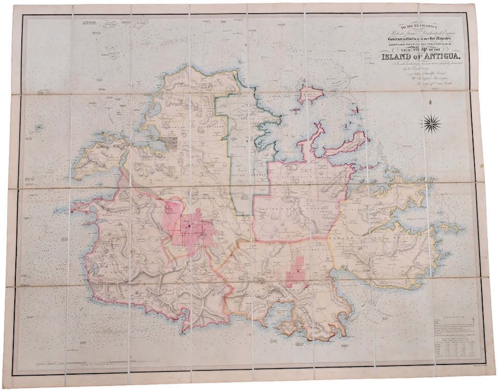
Map of Antigua sails to over 20-times estimate
23 May 2022Estimated at just $200-300, this folding map of the island of Antigua proved rather more expensive than expected.
London Map Fair: Discoveries new and old
16 May 2022Dealer Tim Bryars previews this year’s London Map Fair with an eye on current collecting trends
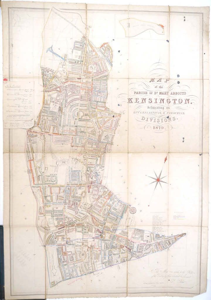
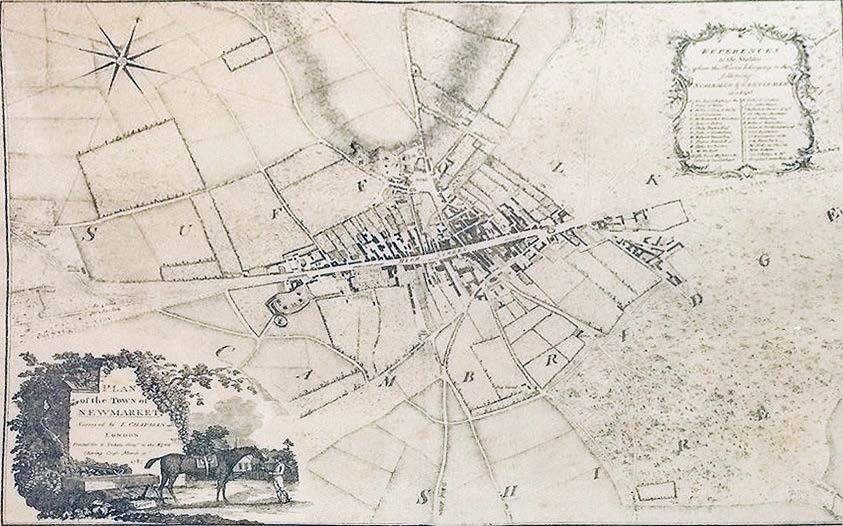
Kensington mapped out and Le Carré in a designer jacket
11 April 2022Bid to £2800 in a recent Norfolk sale was a detailed and now rare Map of the Parish of St Mary Abbotts, Kensington… dating from 1879.
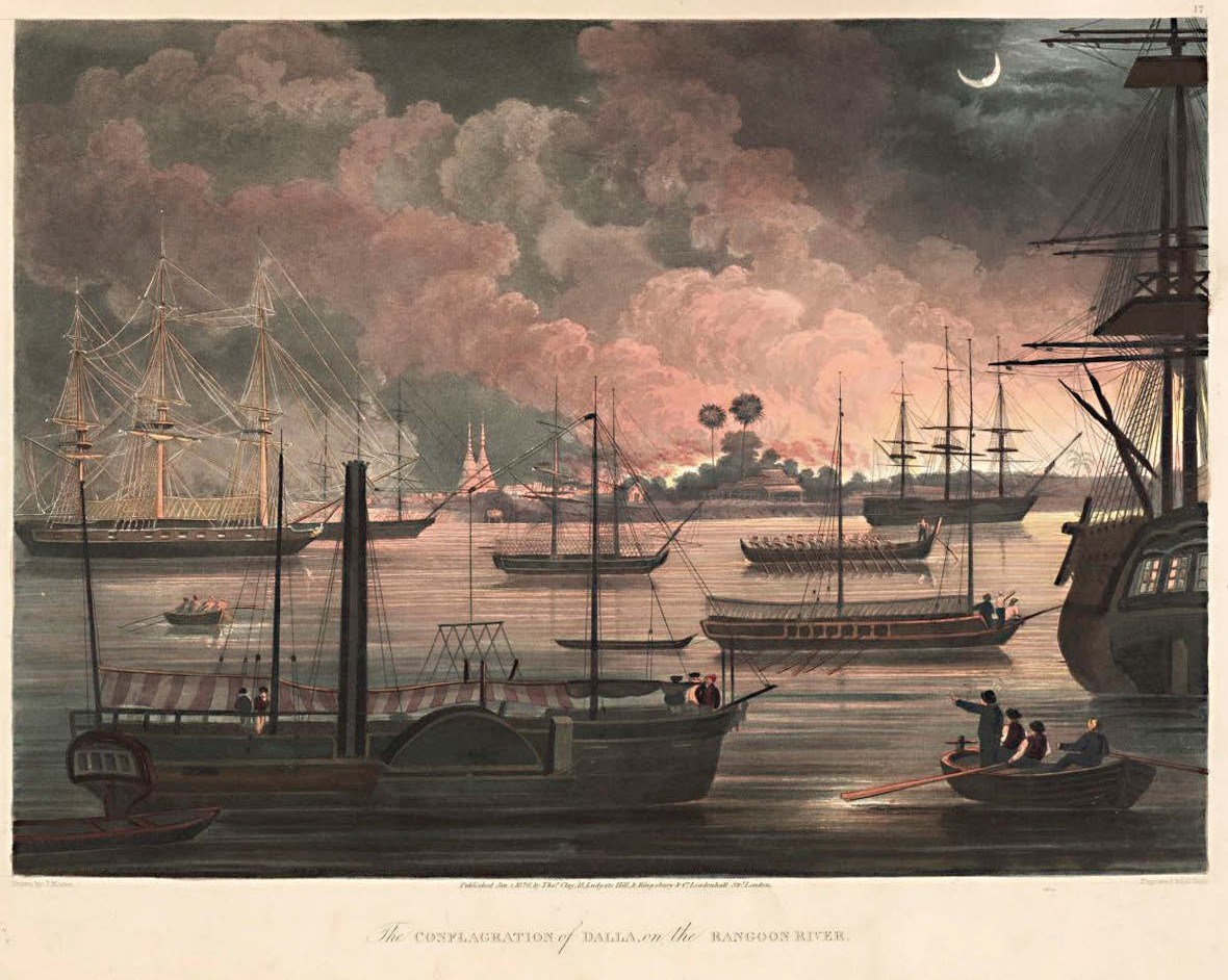
Burmese blaze and golden gains
07 March 2022Nineteenth century aquatint and map provide global perspective in Gloucestershire saleroom
Curious but costly world view
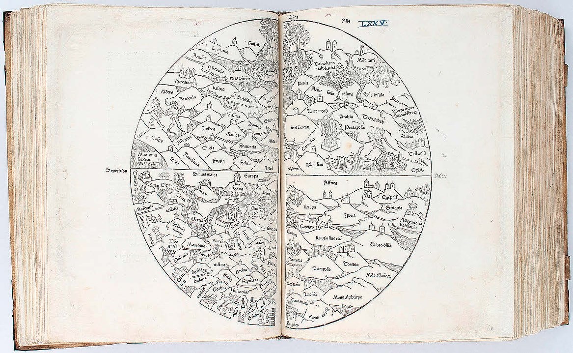
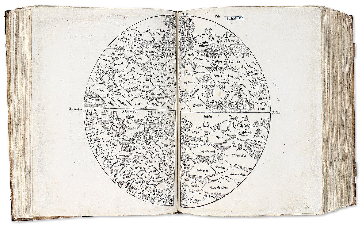
17 January 2022In Rodney Shirley’s monumental study of 'The Mapping of the World… 1472-1700', the very first entry is a simple, circular woodcut known as a ‘T-O’ map, one in which the continents of Asia, Europe and Africa are very simply shown as named segments.
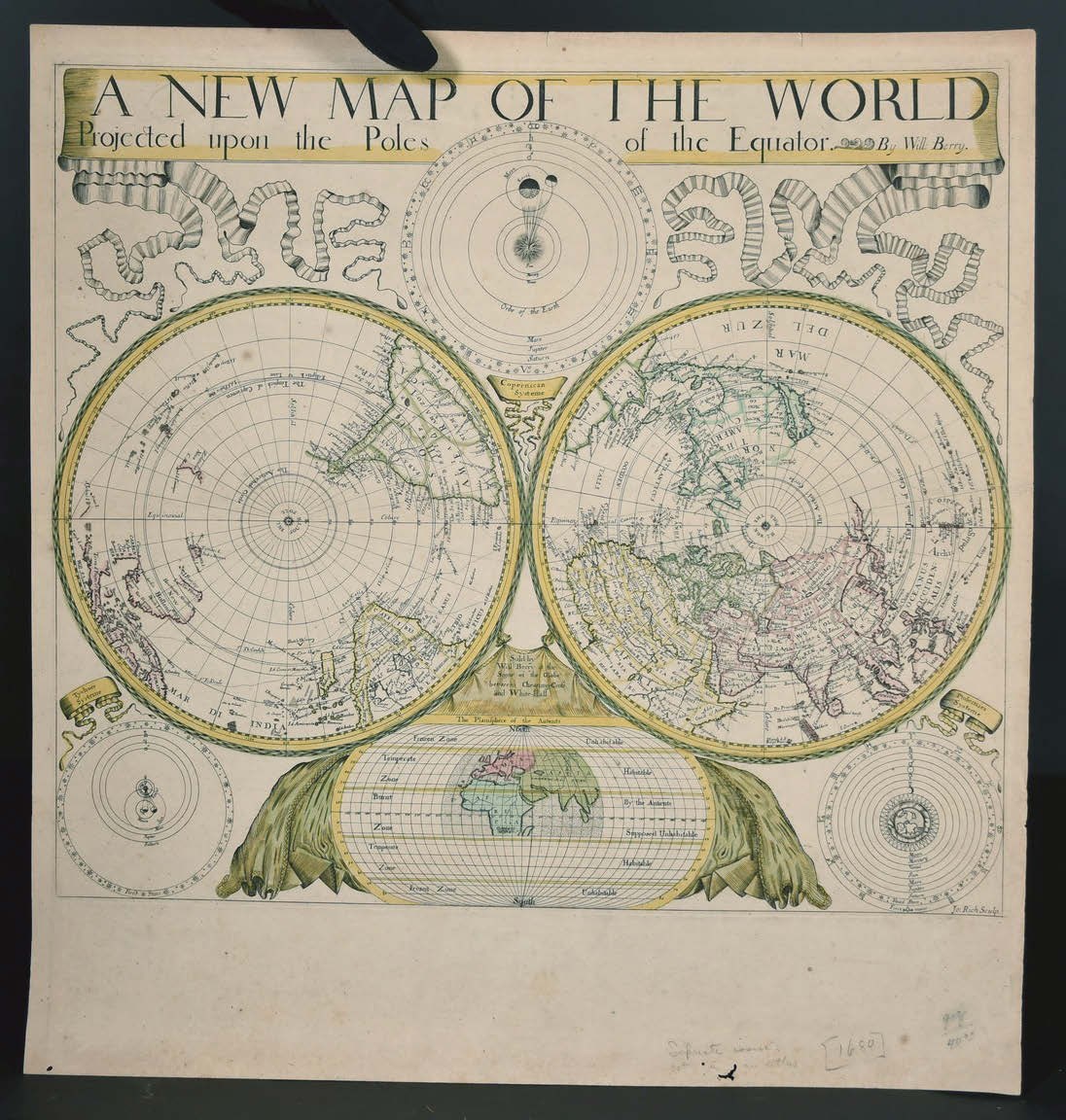
Pick of the week: Berry map rarity takes pole position
10 January 2022Relatively few English mapmakers came to the fore in the 17th century at a time when Dutch cartographers were well ahead of the competition.
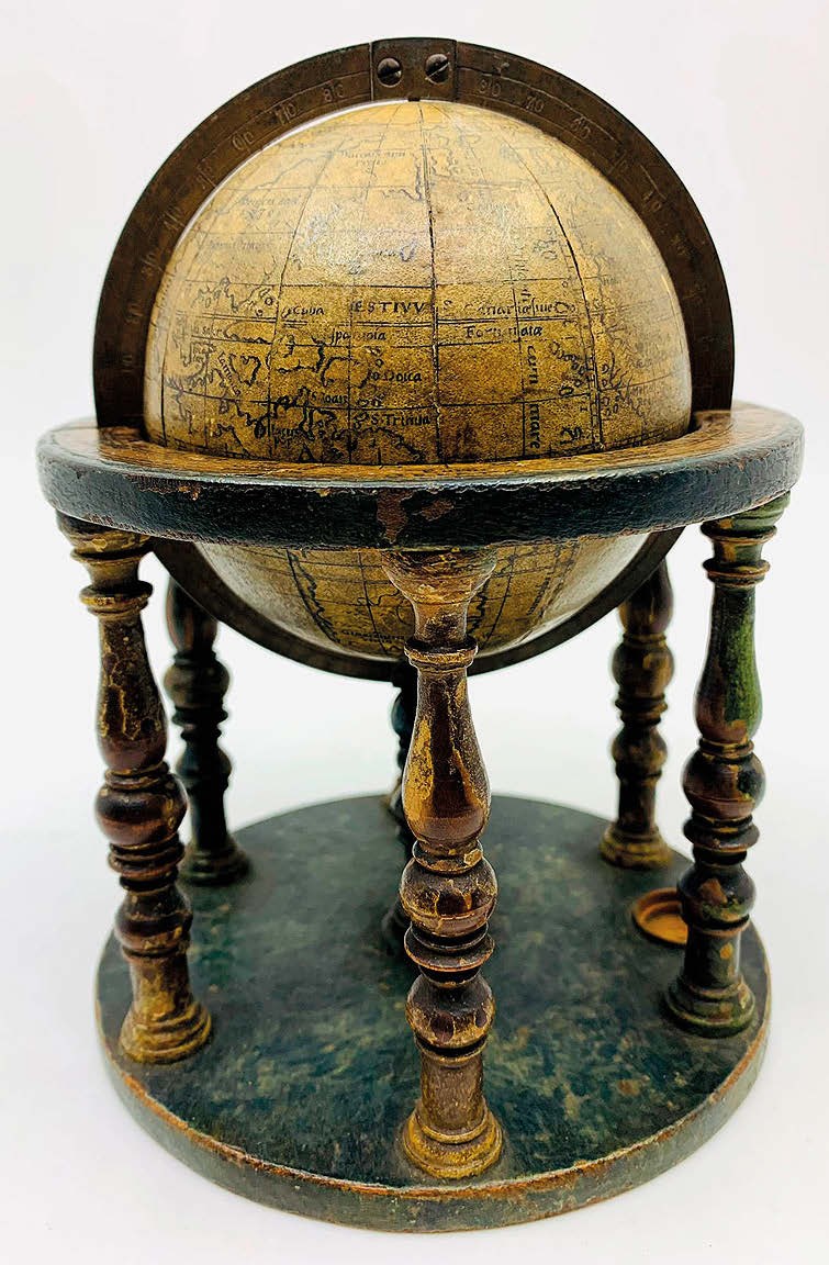
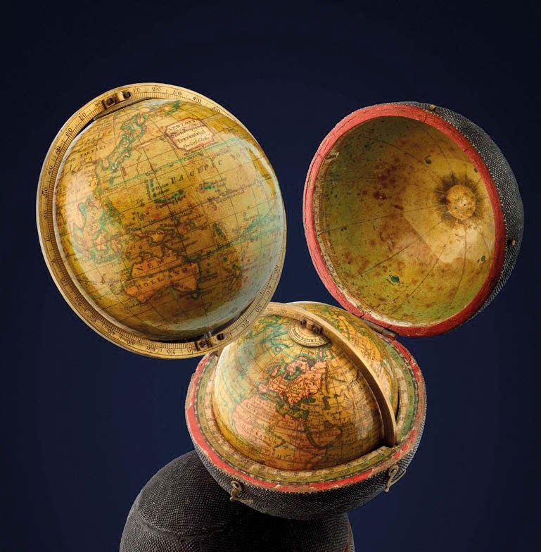
Pick of the week: A round the world trip in the 1560s
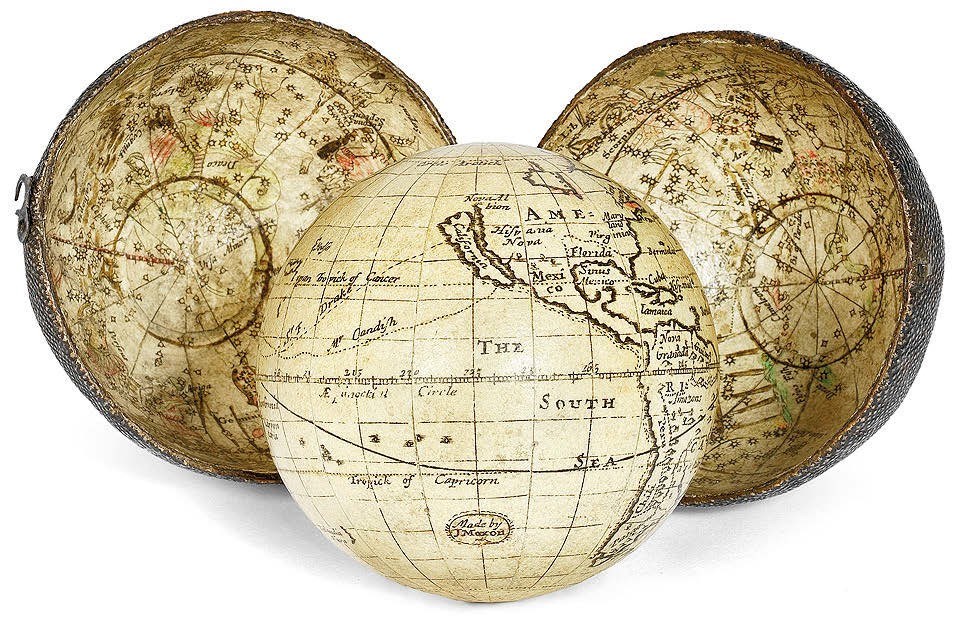
03 January 2022Sixteenth-century globes rarely appear on the market. So, Jim Spencer, Hansons’ works on paper specialist, had been amazed to encounter one at a valuation day in Bishton Hall, Staffordshire.
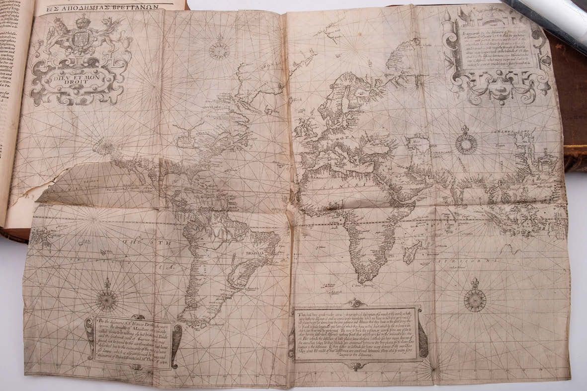
The Wright map that plots a route to £365,000
20 December 2021A copy of Richard Hakluyt’s 'The Principal Navigations, Voiages, Traffiques and Discoveries of the English Nation' takes a six-figure sum at Devon sale.
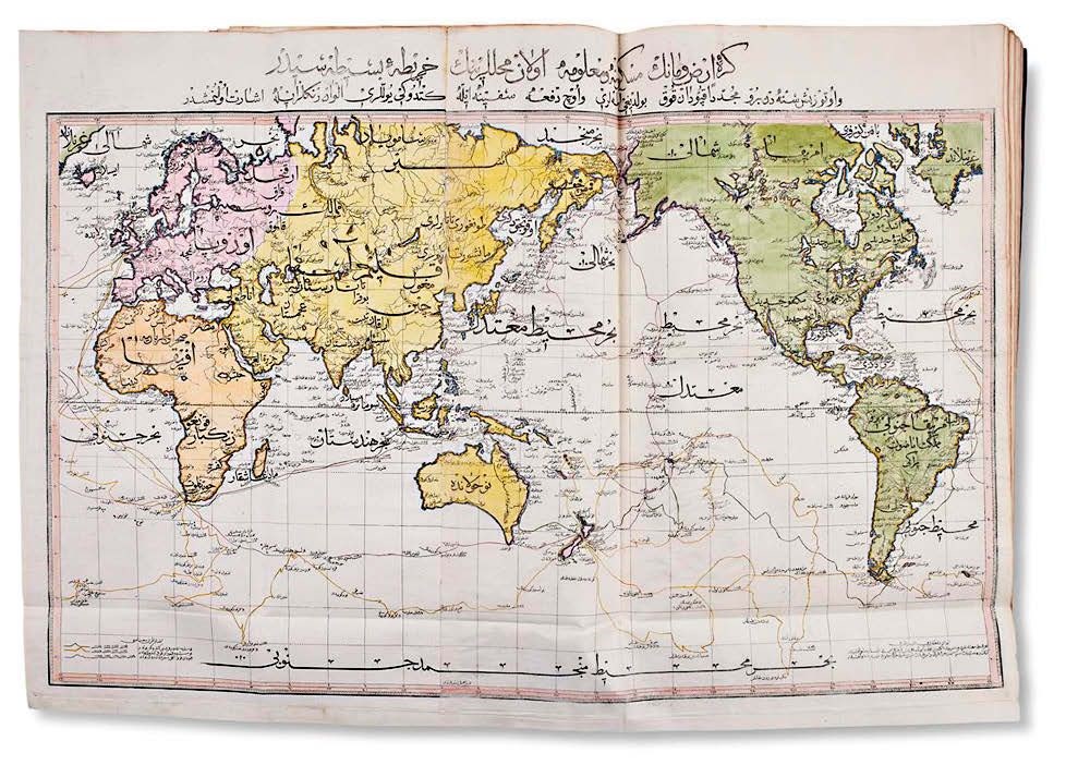
Pick of the week: The Ottoman view of the world
22 November 2021A copy of the first folio atlas ever printed in the Islamic world has sold for £69,000 (plus 25% buyer’s premium) – the highlight of the first day of Dreweatts’ sale titled Weston Hall and the Sitwells: A Family Legacy.
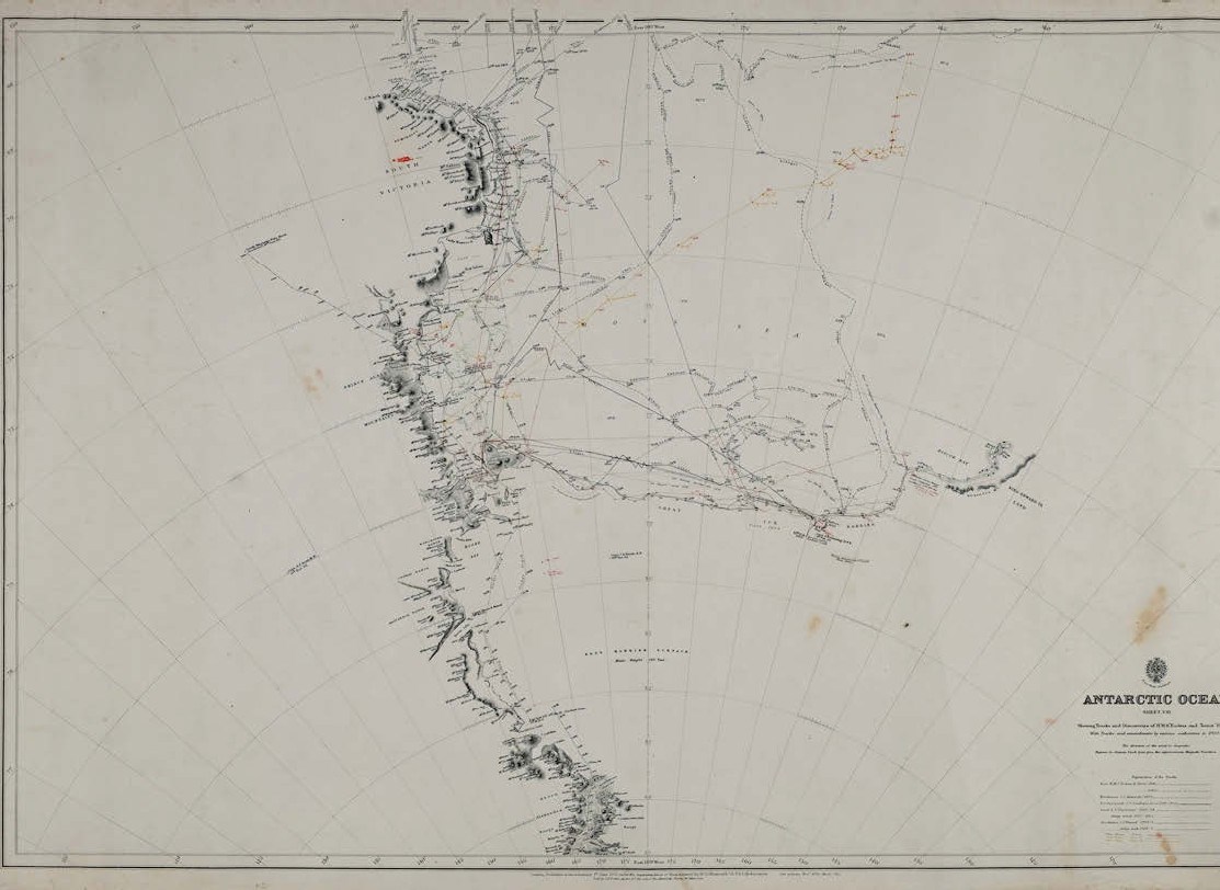
Carpenter’s hits include chart toppers
01 November 2021Antarctic maps take highest prices in collection relating to key Terra Nova crew member
Maps and plans make a mark
27 October 2021Stand-out cartographic lots sold in Gloucestershire include a string of early rarities
Complete copy of the first folio atlas ever printed in the Islamic world
11 October 2021This complete copy of the first folio atlas ever printed in the Islamic world was discovered in one of the nine attics at Weston Hall in Northamptonshire, home of the Sitwell family for more than 300 years.
Atlas pathfinder up at auction
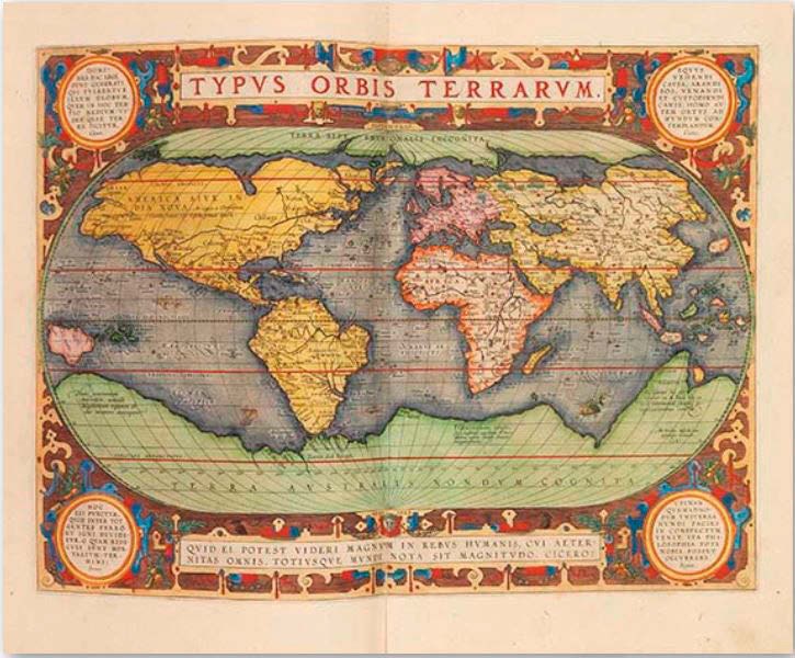
11 October 2021A copy of the first modern atlas by Abraham Ortelius, which set the standard for all following atlases, will be on offer at Ketterer Kunst in Hamburg on November 29 with an estimate of €80,000.
Printed map pioneer appears in massive German auction
11 October 2021Like Antiques Trade Gazette, German biblio auction house Reiss & Sohn is marking its 50th anniversary this year.
Pick of the week: How to get the whole world in your hands
27 September 2021Fascinated both by their elegance of design and sophisticated cartography, Stephen Edell began collecting globes 50 years ago.
Climate change collection sounds the alarm
27 September 2021With the UN Climate Change Conference 2021 (COP26) on the horizon, rare books specialist Peter Harrington is using Frieze Masters to launch an ambitious new collection of books and original manuscripts charting the history of climate change and environmentalism.
Pocket globes point to Bavarian event
09 August 2021The organisers of the Bamberger Kunst-und Antiquitätenwochen (art and antiques weeks), which run until August 22, thought long and hard about whether to hold this year’s event in light of the pandemic.
Pick of the week: Demand for Georgian print is racing certainty
19 July 2021A rare Georgian print on a sporting theme was offered by Northumberland auction house.
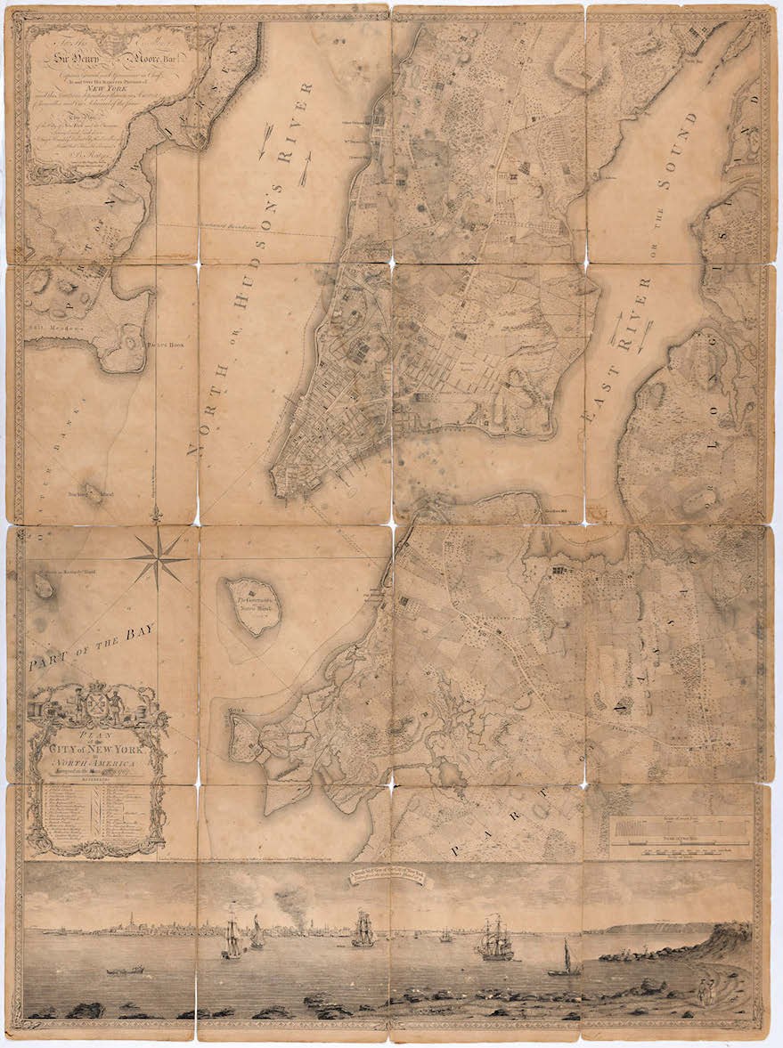
Defective plan of New York still in demand
28 June 2021A copy of Ratzer’s 'Plan of the City of New York…' offered as part of a Doyle (26/21/15% buyer’s premium) sale in the spring left much to be desired.
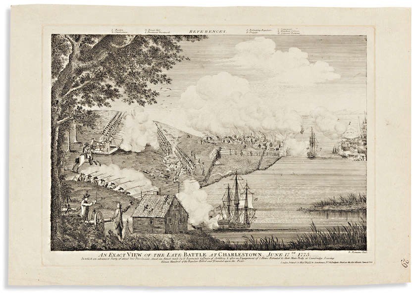
Into US battle – the English version
14 June 2021An Americana sale held by Swann (25/20/12% buyer’s premium) was led at $55,000 (£39,855) by an 1830, Palmyra first of 'The Book of Mormon'.

- Bellmans
- Antiques & Interiors
- 03 Aug 2026 - 01:00 AM
- Cadmore Auctions
- Jewellery, Watches, Design, Militaria, Asian Art & Collectables
- 03 Aug 2026 - 01:00 AM
- Canterbury Auction Galleries
- Antiques & Collectables
- 03 Aug 2026 - 01:00 AM
- Churchill Auctions
- Antiques & Collectables
- 03 Aug 2026 - 01:00 AM
- Gorringe's
- House & Garden
- 03 Aug 2026 - 09:30 AM
- Paul Beighton Auctioneers
- Antiques & Collectables
- 03 Aug 2026 - 10:00 AM

Categories
-
- Arms, Armour & Militaria
- Bank notes
- Books & Periodicals
- Cameras & Camera Equipment
- Classic Cars, Motorcycles & Automobilia
- Coins
- Collectables
- Entertainment Memorabilia
- Kitchenalia
- Maps
- Models, Toys, Dolls & Games
- Musical Instruments & Memorabilia
- Scientific Instruments
- Sporting Memorabilia & Equipment
- Stamps
- Taxidermy & Natural History
- Tools
- Wines & Spirits
- Writing Instruments
News
-
- Art finance
- Auctions
- Brexit
- Buyer's and seller's premiums
- Coronavirus
- Delivery and Shipping
- Education and Training
- Endangered Species
- Events and conferences
- Industry data
- Insurance
- Internet
- Law, crime and regulation
- Museum acquisitions
- Museum deaccessioning
- New books
- Obituaries
- Premises and Property
- Price Reporter
- Private Sales
- Recruitment
- Restoration
- TV shows
-
- 1818 Auctioneers
- Adam Partridge
- Adam's
- Addisons
- Ader
- Aguttes
- Alastair Gibson Auctions
- Alcala Subastas
- Aldridges
- Amersham Auction Rooms
- Anderson & Garland
- Andrew Smith & Son
- Anthemion
- AntikBar
- Antony Cribb
- Apollo Art Auctions
- Artcurial
- Arthur Johnson & Sons
- Artvisory
- Aston's
- Aubreys
- Auction Team Breker
- Auctionata
- Auctioneum
- Azca Auctions
- Babuino
- Bainbridge Adam Partridge
- Baldwin's
- Bamfords
- Barbers
- Batemans
- BBR Auctions
- Bearnes Hampton & Littlewood
- Beaussant Lefèvre
- Bellmans
- Bentley’s
- Biddle & Webb
- Bigwood
- Bishop & Miller
- Bleasdales
- Bloomsbury Auctions
- Boldon Auction Galleries
- Bonhams
- Bonhams Skinner
- Bosleys
- Bourne End Auction Rooms
- Brettells
- Brighton General Auctions
- Brightwells
- Bristol Auction Rooms
- Brown & Co
- Bruun Rasmussen
- Burstow & Hewett
- Byrnes
- C&T
- Cambi Casa d'Aste
- Canterbury Auction Galleries
- Capes Dunn
- Catherine Southon
- Cato Crane
- Chalkwell
- Charles Miller
- Charles Ross Auctioneers
- Charterhouse
- Cheffins
- Chilcotts
- Chippenham Auction Rooms
- Chiswick Auctions
- Chorley's
- Christie's
- Clarke & Simpson
- Clars Auction Gallery
- Clevedon Salerooms
- Comic Book Auctions
- Cotswold Auction Company
- Cottees
- Cowans
- Criterion
- Crow’s Auctions Gallery
- Curated Auctions
- Cuttlestones
- Czerny
- David Duggleby
- Dawsons
- Denhams
- Dominic Winter
- Dore & Rees
- Dorotheum
- Doyle New York
- Dreweatts
- Duke's
- Durrants
- Eastbourne Auctions
- Eldreds
- Elmwood’s
- Elstob Auctioneers
- Ewbank's
- Featonby's
- Fellows
- Fieldings
- Fine Art Auction Group
- Fine Art Bourse
- Flints Auctioneers
- Fonsie Mealy
- Forum Auctions
- Frank Marshall
- Freeman's
- Gardiner Houlgate
- Gary Don
- George Kidner
- Gerrards Auction Rooms
- Gildings
- Golding Young & Mawer
- Gorringe's
- Graham Budd
- Grand Auctions
- Great Western Auctions
- Greenslade Taylor Hunt
- Gros & Delettrez
- H&H Classics
- Halls Fine Art
- Hampstead Auctions
- Hannam’s
- Hansons
- Harper Field
- Hartleys
- Henry Adams
- Henry Aldridge & Son
- Heritage Auctions
- Hermann Historica
- High Road Auctions
- Hindman
- Holloways
- Holt's
- Hôtel Drouot
- Hotlotz
- Humbert & Ellis
- Hutchinson Scott
- Irita Marriott
- Jacobs & Hunt
- John Nicholson
- John Pye Auctions
- Jones & Jacob
- JS Fine Art
- Jubilee Auction Rooms
- Juliens
- Kerry Taylor
- KettererKunst
- Keys
- Kidson-Trigg
- Kinghams
- Kings Russell
- Knights Auctions
- Knowle Auction Rooms
- Koller
- Lacy Scott & Knight
- Laidlaw
- Lawrences of Bletchingley
- Lawrences of Crewkerne
- Lay’s Auctioneers
- Lempertz
- Leonard Joel
- Lindsay Burns
- Littleton
- Lockdales
- Locke & England
- London Auctions
- Lots Road Auctions
- Louis Taylor
- Lyon & Turnbull
- MacDougall's
- Mallams
- Mander
- Marlows of Stafford
- Martel Maides
- Maxwells
- McTear's
- Mellors & Kirk
- Michael Bowman
- Millon
- Minster Auctions
- Mitchells
- Moore Allen & Innocent
- Morphets
- Morton & Eden
- Mossgreen
- Mulberry Bank Auctions
- Mullock Jones
- Nagel
- Nesbits
- Netherhampton Salerooms
- Nicholas Mellors
- Nigel Ward
- Noble Investments
- Noonans
- Olympia Auctions
- Omega Auctions
- Onslows
- Osenat
- Paddle8
- Parker Fine Art Auctions
- Paul Beighton Saleroom
- PBA Galleries
- Peter Francis
- Philip Serrell
- Phillips
- Piasa
- Pierre Bergé & Associes
- Piers Motley
- Plymouth Auction Rooms
- Potter & Potter
- Potteries Auctions
- Rago Auctions
- Railtons
- Ramsay Cornish
- Reeman Dansie
- Rendells
- Richard Edmonds Auctions
- Richard Winterton
- Ritchies
- RM Sotheby’s
- Rogers Jones
- Roma Numismatics
- Roseberys
- Ross’s of Belfast
- Rowley's
- Rushbrooks
- RWB Auctions
- Ryedale
- Semley
- Sheffield Auction Gallery
- Sheppard’s
- Silverwoods
- Sloane Street Auctions
- Sotheby's
- Sovereign Rarities
- Special Auction Services
- Spicers
- Spink
- St Jamess Auctions
- Staceys
- Stanley Gibbons Group
- Sterling Vault Auctioneers
- StockholmsAuktionsverk
- Stride & Son
- Summers Place Auctions
- Swan Fine Art Auctioneers
- Swann
- Sworders
- Tajan
- Tamlyns
- Tayler and Fletcher
- Taylor's Auctions
- Tennants
- The Pedestal
- Thimbleby & Shorland
- Thomas Del Mar
- Thomas N Miller
- Thomas R Callan
- Thomas Watson
- Thomaston Place
- Thomson Roddick & Medcalf
- Thomson Roddick Scottish Auctions
- Timeline
- Toovey's
- Trevanion
- Truro Auction Centre
- TW Gaze
- Unique Auctions
- Vectis
- Veritas
- W&H Peacock
- Wallis and Wallis
- Warren & Wignall
- Watches of Knightsbridge
- Wellers Auctions
- Wessex Auction Rooms
- Whitton & Laing
- Whittons
- Whytes
- Wilkes & Curtis
- Wilkinson's Auctioneers
- William George & Co
- Wilson55
- Wimbledon Auctions
- Woolley & Wallis
- Wotton Auction Rooms
- Wright Marshall
-
- 1stdibs
- Advertising Standards Authority
- Antiquarian Booksellers Association
- Antique Young Guns
- Antiquities Dealers’ Association
- Art Business Conference
- Art Fund
- Art Loss Register
- Art Recovery International
- Art UK
- Artists' Collecting Society
- Arts Council England
- Assay Office
- Auction Technology Group
- BADA
- BAMF
- CADA
- CINOA
- Company of Arts Scholars
- DACS
- DEFRA
- DMG
- EBay
- Hiscox
- LAPADA
- Lot-tissimo
- National Trust
- NAVA
- Provincial Booksellers Fairs Association
- RICS
- Society of London Art Dealers
- SOFAA
- the saleroom
- Triple-A Auctioneers
-
- Adams Antiques Fairs
- Affordable Art Fair
- Alexandra Palace fair
- Antiques Centres
- Antiques Dealers Fair Limited
- Ardingly Fair
- Armchair Art Fair
- Art & Antiques for Everyone Fair
- Art Antiques London
- Art, Antiques & Interiors Expo
- Arthur Swallow Fairs
- Bath Decorative Antiques Fair
- Battersea Decorative Fair
- Bermondsey Market
- Book Fairs
- BRAFA
- British Art Fair
- Brussels Fairs
- CADA Fair
- Car Boot Fairs
- Clarion Events
- Classic Antique Fairs
- Continuity Fairs
- Cooper Events
- Ephemera fairs
- Fine Art Asia
- Fine Arts Paris
- Firsts
- Florida Fairs
- French Fairs
- Frieze
- Frieze Masters
- Galloway Antiques Fairs
- Harrogate Fairs
- Hatton Garden
- Haughton Fairs
- Hong Kong Fairs
- IACF
- Jaguar Fairs
- LAPADA Fair
- Lincolnshire Antiques and Home Show
- London Original Print Fair
- Masterpiece
- Miami Fairs
- Midcentury Modern
- Modern British Art Fair
- NEC Birmingham
- New York Fairs
- Newark Fair
- Newbury Antiques and Collectors Fair
- Olympia Fair
- PAD London
- Palm Beach Fairs
- Paris Biennale
- Paris Fairs
- Paris Parcours
- Paris Tableau
- Penman Fairs
- Philadelphia Fairs
- Photography fairs
- Regional Fairs
- Salon du Dessin
- Sandown Park Racecourse Fair
- Showground Fairs
- Swinderby Fair
- TEFAF
- The Open Art Fair
- The Treasure House Fair
- The Winter Show
- Works on Paper Fair
-
- Alfred Taubman
- Bendor Grosvenor
- Bill Ruprecht
- Charles Hanson
- Charlie Ross
- Cornelius Gurlitt
- David Lester
- Ed Dolman
- Eric Knowles
- François Pinault
- Ingrid Nilson
- Lennox Cato
- Lord Ashcroft
- Marco Forgione
- Mark Law
- Sheikh Saud Bin Mohammed Al-Thani
- Simon de Pury
- Sue Ede
- Tad Smith
- Tim Goodman
- Victoria Borwick
-
- Abbott and Holder
- Agnews
- Alastair Dickenson
- Andrew Sim
- Blairman
- Carter Marsh
- Colnaghi
- Daniel Katz
- Dickinson
- Fabrizio Moretti
- Ian Towning
- Johnny Van Haeften
- London Silver Vaults
- Mallett
- Marchant
- Mark Weiss
- Partridge Fine Art
- Petworth Antiques Dealers
- Philip Mould
- Pimlico Road Dealers
- Richard Green
- Robert Young
- Roger Keverne
- Rupert Maas
- SJ Phillips
- Wartski
-
- A Lawyer Writes
- Around the Auction Houses
- Art Market
- Auction Reports
- Bid Barometer
- Books and Works on Paper
- Dealers' Diary
- Fairs, Markets, Shops and Centres
- Features
- Front Page and News
- International (print edition)
- Interviews
- Letters to the Editor
- Life in the Trade
- News in Brief
- Obituaries (print edition)
- Opinion
- Pick of the Week
- Precious Metals Prices
- Previews
- Soapbox
- Special Reports
- Then & Now